FAA-H-8083-25C · Source PDF page 207
Flight Instruments
Setting the Altimeter · PHAK page 8-5
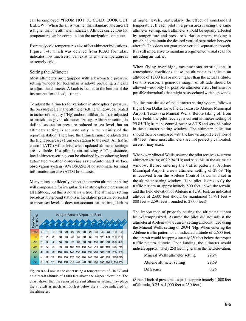
Searchable transcription
Height Above Airport in Feet
+10 10 10 10 10 20 20 20 20 20 30 40 60 80 90
0 20 20 30 30 40 40 50 50 60 90 120 170 230 280
-10 20 30 40 50 60 70 80 90 100 150 200 290 390 490
-20 30 50 60 70 90 100 120 130 140 210 280 420 570 710
-30 40 60 80 100 120 140 150 170 190 280 380 570 760 950
-40 50 80 100 120 150 170 190 220 240 360 480 720 9701,210
-50 60 90 120 150 180 210 240 270 300 450 590 890 1,1901,500
Figure 8-4. Look at the chart using a temperature of –10 °C and
an aircraft altitude of 1,000 feet above the airport elevation. The
chart shows that the reported current altimeter setting may place
the aircraft as much as 100 feet below the altitude indicated by
the altimeter.
8-5
detropeR
C°
0
pmeT
can be employed: “FROM HOT TO COLD, LOOK OUT at higher levels, particularly the effect of nonstandard
BELOW.” When the air is warmer than standard, the aircraft temperature. If each pilot in a given area is using the same
is higher than the altimeter indicates. Altitude corrections for altimeter setting, each altimeter should be equally affected
temperature can be computed on the navigation computer. by temperature and pressure variation errors, making it
possible to maintain the desired vertical separation between
Extremely cold temperatures also affect altimeter indications. aircraft. This does not guarantee vertical separation though.
Figure 8-4, which was derived from ICAO formulas, It is still imperative to maintain a regimented visual scan for
indicates how much error can exist when the temperature is intruding air traffic.
extremely cold.
When flying over high, mountainous terrain, certain
Setting the Altimeter atmospheric conditions cause the altimeter to indicate an
Most altimeters are equipped with a barometric pressure altitude of 1,000 feet or more higher than the actual altitude.
setting window (or Kollsman window) providing a means For this reason, a generous margin of altitude should be
to adjust the altimeter. A knob is located at the bottom of the allowed—not only for possible altimeter error, but also for
instrument for this adjustment. possible downdrafts that might be associated with high winds.
To adjust the altimeter for variation in atmospheric pressure, To illustrate the use of the altimeter setting system, follow a
the pressure scale in the altimeter setting window, calibrated flight from Dallas Love Field, Texas, to Abilene Municipal
in inches of mercury ("Hg) and/or millibars (mb), is adjusted Airport, Texas, via Mineral Wells. Before taking off from
to match the given altimeter setting. Altimeter setting is Love Field, the pilot receives a current altimeter setting of
defined as station pressure reduced to sea level, but an 29.85 "Hg from the control tower or ATIS and sets this value
altimeter setting is accurate only in the vicinity of the in the altimeter setting window. The altimeter indication
reporting station. Therefore, the altimeter must be adjusted as should then be compared with the known airport elevation of
the flight progresses from one station to the next. Air traffic 487 feet. Since most altimeters are not perfectly calibrated,
control (ATC) will advise when updated altimeter settings an error may exist.
are available. If a pilot is not utilizing ATC assistance,
local altimeter settings can be obtained by monitoring local When over Mineral Wells, assume the pilot receives a current
automated weather observing system/automated surface altimeter setting of 29.94 "Hg and sets this in the altimeter
observation system (AWOS/ASOS) or automatic terminal window. Before entering the traffic pattern at Abilene
information service (ATIS) broadcasts. Municipal Airport, a new altimeter setting of 29.69 "Hg
is received from the Abilene Control Tower and set in
Many pilots confidently expect the current altimeter setting the altimeter setting window. If the pilot desires to fly the
will compensate for irregularities in atmospheric pressure at traffic pattern at approximately 800 feet above the terrain,
all altitudes, but this is not always true. The altimeter setting and the field elevation of Abilene is 1,791 feet, an indicated
broadcast by ground stations is the station pressure corrected altitude of 2,600 feet should be maintained (1,791 feet +
to mean sea level. It does not account for the irregularities 800 feet = 2,591 feet, rounded to 2,600 feet).
The importance of properly setting the altimeter cannot
be overemphasized. Assume the pilot did not adjust the
200 300 400 500 600 700 800 900
1,000 1,500 2,000 3,000 4,000 5,000 a
th
lt
e
i m
M
e
i
t
n
er
e r
a
a
t
l
A
W
bi
e
le
ll
n
s
e
s
t
e
o
t t
t
i
h
n
e
g
c
o
u
f
r r
2
e
9
n
.
t
9
s
4
e t
"
ti
H
ng
g .
a
W
nd
h
c
e
o
n
n t
e
i
n
n
t
u
e
e
r
d
in
u
g
s i
t
n
h
g
e
Abilene traffic pattern at an indicated altitude of 2,600 feet,
the aircraft would be approximately 250 feet below the proper
traffic pattern altitude. Upon landing, the altimeter would
indicate approximately 250 feet higher than the field elevation.
Mineral Wells altimeter setting 29.94
Abilene altimeter setting 29.69
Difference 0.25
(Since 1 inch of pressure is equal to approximately 1,000 feet
of altitude, 0.25 × 1,000 feet = 250 feet.)