FAA-H-8083-25C · Source PDF page 308
Weather Theory
Icing · PHAK page 12-24
Searchable transcription
Turbulence
Anvil
Storm movement
Roll cloud
Wind shear turbulence
Wind shear turbulance
First gust
Dust
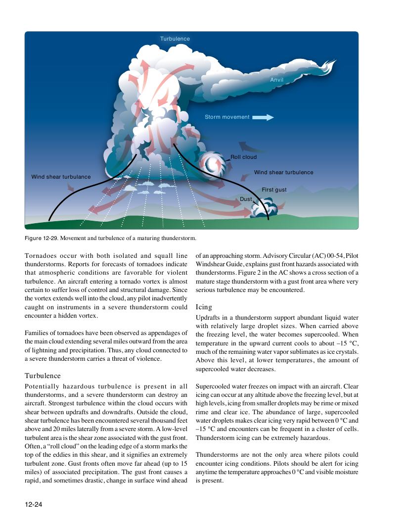
Figure 12-29. Movement and turbulence of a maturing thunderstorm.
Tornadoes occur with both isolated and squall line of an approaching storm. Advisory Circular (AC) 00-54, Pilot
thunderstorms. Reports for forecasts of tornadoes indicate Windshear Guide, explains gust front hazards associated with
that atmospheric conditions are favorable for violent thunderstorms. Figure 2 in the AC shows a cross section of a
turbulence. An aircraft entering a tornado vortex is almost mature stage thunderstorm with a gust front area where very
certain to suffer loss of control and structural damage. Since serious turbulence may be encountered.
the vortex extends well into the cloud, any pilot inadvertently
caught on instruments in a severe thunderstorm could Icing
encounter a hidden vortex. Updrafts in a thunderstorm support abundant liquid water
with relatively large droplet sizes. When carried above
Families of tornadoes have been observed as appendages of the freezing level, the water becomes supercooled. When
the main cloud extending several miles outward from the area temperature in the upward current cools to about –15 °C,
of lightning and precipitation. Thus, any cloud connected to much of the remaining water vapor sublimates as ice crystals.
a severe thunderstorm carries a threat of violence. Above this level, at lower temperatures, the amount of
supercooled water decreases.
Turbulence
Potentially hazardous turbulence is present in all Supercooled water freezes on impact with an aircraft. Clear
thunderstorms, and a severe thunderstorm can destroy an icing can occur at any altitude above the freezing level, but at
aircraft. Strongest turbulence within the cloud occurs with high levels, icing from smaller droplets may be rime or mixed
shear between updrafts and downdrafts. Outside the cloud, rime and clear ice. The abundance of large, supercooled
shear turbulence has been encountered several thousand feet water droplets makes clear icing very rapid between 0 °C and
above and 20 miles laterally from a severe storm. A low-level –15 °C and encounters can be frequent in a cluster of cells.
turbulent area is the shear zone associated with the gust front. Thunderstorm icing can be extremely hazardous.
Often, a “roll cloud” on the leading edge of a storm marks the
top of the eddies in this shear, and it signifies an extremely Thunderstorms are not the only area where pilots could
turbulent zone. Gust fronts often move far ahead (up to 15 encounter icing conditions. Pilots should be alert for icing
miles) of associated precipitation. The gust front causes a anytime the temperature approaches 0 °C and visible moisture
rapid, and sometimes drastic, change in surface wind ahead is present.
12-24