FAA-H-8083-25C · Source PDF page 305
Weather Theory
W AR · PHAK page 12-21
Searchable transcription
C
O
L
D
A WARM AIR
I
R
CUMULONIMBUS
Indianapolis Columbus Pittsburgh
St. Louis
200 miles 400 miles 600 miles
1008 1005 1005 1008
1011 METAR KSTL 1950Z 30018KT 10SM
SCT010 08/02 A2979
74 071
1011 4 1 3 6 0 3 0 4 6 2 6 7 3 1 10 4 7 7 7 6 3 102 8 7 7 5 3 0 12 1 2 2 M E T A R K O I V N C D 0 10 1 950Z 2 2 0 4 0 /2 2 3 4 K T 3 A S 2 M 97 4 +TSRA
25
St. 1 L 0 ouis Indianapolis Columbus Pit 3 t 5 sburgh METAR KCMH 1950Z 20012KT 6SM HZ
1014 BKN025 25/24 A2983
METAR KPIT 1950Z 20012KT 3SM FU
SCT035 24/22 A2989
1011 1011 1014
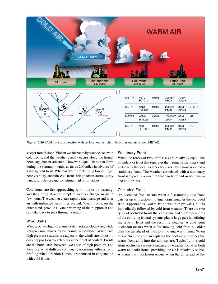
Figure 12-26. Cold front cross-section with surface weather chart depiction and associated METAR.
steeper frontal slope. Violent weather activity is associated with Stationary Front
cold fronts, and the weather usually occurs along the frontal When the forces of two air masses are relatively equal, the
boundary, not in advance. However, squall lines can form boundary or front that separates them remains stationary and
during the summer months as far as 200 miles in advance of influences the local weather for days. This front is called a
a strong cold front. Whereas warm fronts bring low ceilings, stationary front. The weather associated with a stationary
poor visibility, and rain, cold fronts bring sudden storms, gusty front is typically a mixture that can be found in both warm
winds, turbulence, and sometimes hail or tornadoes. and cold fronts.
Cold fronts are fast approaching with little or no warning, Occluded Front
and they bring about a complete weather change in just a An occluded front occurs when a fast-moving cold front
few hours. The weather clears rapidly after passage and drier catches up with a slow-moving warm front. As the occluded
air with unlimited visibilities prevail. Warm fronts, on the front approaches, warm front weather prevails but is
other hand, provide advance warning of their approach and immediately followed by cold front weather. There are two
can take days to pass through a region. types of occluded fronts that can occur, and the temperatures
of the colliding frontal systems play a large part in defining
Wind Shifts the type of front and the resulting weather. A cold front
Wind around a high-pressure system rotates clockwise, while occlusion occurs when a fast moving cold front is colder
low-pressure winds rotate counter-clockwise. When two than the air ahead of the slow moving warm front. When
high pressure systems are adjacent, the winds are almost in this occurs, the cold air replaces the cool air and forces the
direct opposition to each other at the point of contact. Fronts warm front aloft into the atmosphere. Typically, the cold
are the boundaries between two areas of high pressure, and front occlusion creates a mixture of weather found in both
therefore, wind shifts are continually occurring within a front. warm and cold fronts, providing the air is relatively stable.
Shifting wind direction is most pronounced in conjunction A warm front occlusion occurs when the air ahead of the
with cold fronts.
12-21