FAA-H-8083-25C · Source PDF page 306
Weather Theory
W AR M A I R · PHAK page 12-22
Searchable transcription
warm front is colder than the air of the cold front. When this and instability are present, the clouds continue to increase
is the case, the cold front rides up and over the warm front. If in vertical height. Continuous, strong updrafts prohibit
the air forced aloft by the warm front occlusion is unstable, moisture from falling. Within approximately 15 minutes,
the weather is more severe than the weather found in a cold the thunderstorm reaches the mature stage, which is the most
front occlusion. Embedded thunderstorms, rain, and fog are violent time period of the thunderstorm’s life cycle. At this
likely to occur. point, drops of moisture, whether rain or ice, are too heavy
for the cloud to support and begin falling in the form of rain
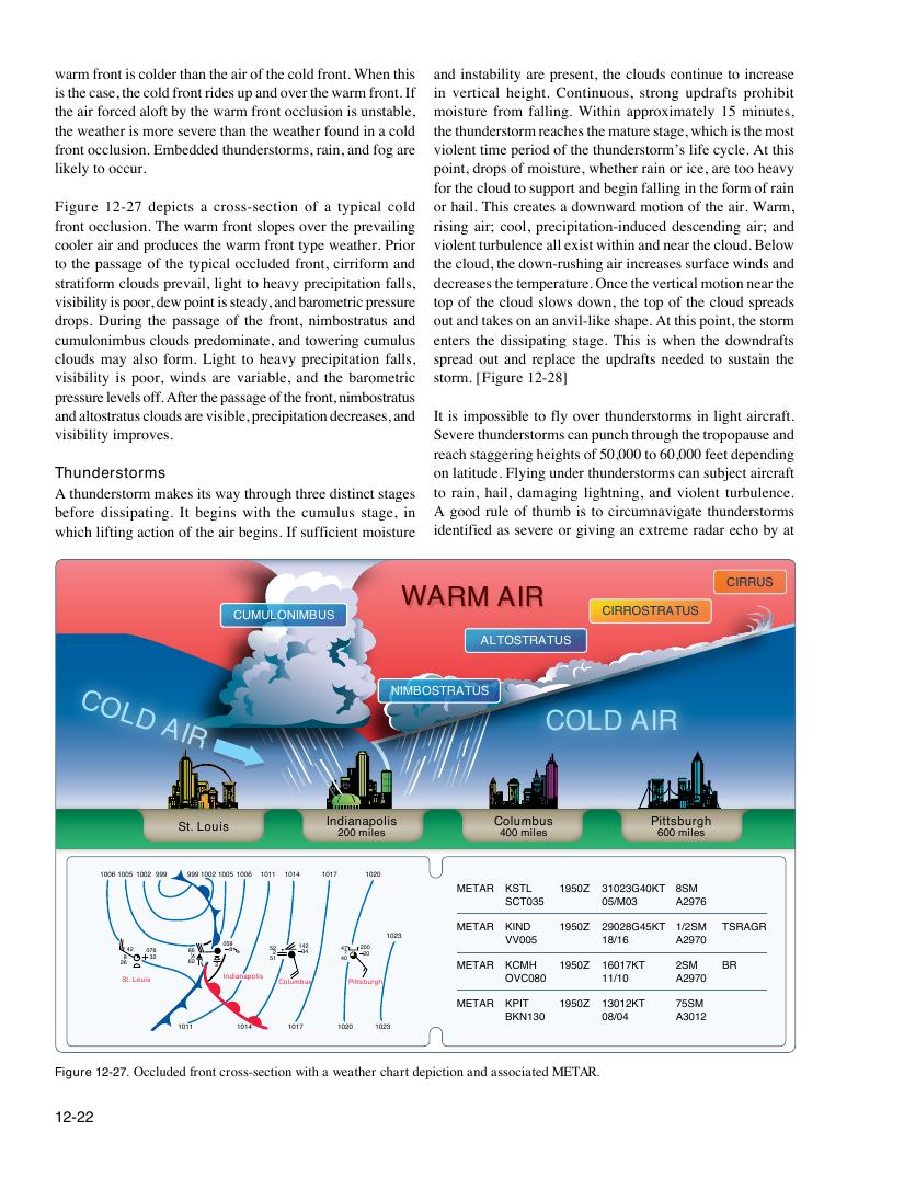
Figure 12-27 depicts a cross-section of a typical cold or hail. This creates a downward motion of the air. Warm,
front occlusion. The warm front slopes over the prevailing rising air; cool, precipitation-induced descending air; and
cooler air and produces the warm front type weather. Prior violent turbulence all exist within and near the cloud. Below
to the passage of the typical occluded front, cirriform and the cloud, the down-rushing air increases surface winds and
stratiform clouds prevail, light to heavy precipitation falls, decreases the temperature. Once the vertical motion near the
visibility is poor, dew point is steady, and barometric pressure top of the cloud slows down, the top of the cloud spreads
drops. During the passage of the front, nimbostratus and out and takes on an anvil-like shape. At this point, the storm
cumulonimbus clouds predominate, and towering cumulus enters the dissipating stage. This is when the downdrafts
clouds may also form. Light to heavy precipitation falls, spread out and replace the updrafts needed to sustain the
visibility is poor, winds are variable, and the barometric storm. [Figure 12-28]
pressure levels off. After the passage of the front, nimbostratus
and altostratus clouds are visible, precipitation decreases, and It is impossible to fly over thunderstorms in light aircraft.
visibility improves. Severe thunderstorms can punch through the tropopause and
reach staggering heights of 50,000 to 60,000 feet depending
Thunderstorms on latitude. Flying under thunderstorms can subject aircraft
A thunderstorm makes its way through three distinct stages to rain, hail, damaging lightning, and violent turbulence.
before dissipating. It begins with the cumulus stage, in A good rule of thumb is to circumnavigate thunderstorms
which lifting action of the air begins. If sufficient moisture identified as severe or giving an extreme radar echo by at
CIRRUS
WARM AIR
CUMULONIMBUS CIRROSTRATUS
ALTOSTRATUS
C NIMBOSTRATUS
O
L
D
A
COLD AIR
IR
Indianapolis Columbus Pittsburgh
St. Louis
200 miles 400 miles 600 miles
10061005 1002 999 999100210051006 1011 1014 1017 1020
METAR KSTL 1950Z 31023G40KT 8SM
SCT035 05/M03 A2976
METAR KIND 1950Z 29028G45KT 1/2SM TSRAGR
1023 VV005 18/16 A2970
2 8 6 42 0 3 7 2 6 6 6 16 22 2 05 8 8 5 5 2 2 1 1 3 4 4 2 4 4 7 7 0 2 2 0 0 0 METAR KCMH 1950Z 16017KT 2SM BR
St. Louis Indianapolis Columbus Pittsburgh OVC080 11/10 A2970
METAR KPIT 1950Z 13012KT 75SM
BKN130 08/04 A3012
1011 1014 1017 1020 1023
Figure 12-27. Occluded front cross-section with a weather chart depiction and associated METAR.
12-22