FAA-H-8083-25C · Source PDF page 409
Navigation
Ground-Based Navigation · PHAK page 16-22
Searchable transcription
• Item 8 is the route of flight. If the flight is to be direct, The prefix “omni-” means all, and an omnidirectional range
enter the word “direct;” if not, enter the actual route to is a VHF radio transmitting ground station that projects
be followed, such as via certain towns or navigation straight line courses (radials) from the station in all directions.
aids. From a top view, it can be visualized as being similar to the
spokes from the hub of a wheel. The distance VOR radials are
• Item 10 is the estimated time en route. In the sample
projected depends upon the power output of the transmitter.
flight plan, 5 minutes was added to the total time to
allow for the climb.
The course or radials projected from the station are referenced
• Item 12 is the fuel on board in hours and minutes. This
to MN. Therefore, a radial is defined as a line of magnetic
is determined by dividing the total usable fuel aboard
bearing extending outward from the VOR station. Radials are
in gallons by the estimated rate of fuel consumption
identified by numbers beginning with 001, which is 1° east
in gallons.
of MN and progress in sequence through all the degrees of a
circle until reaching 360. To aid in orientation, a compass rose
Remember, there is every advantage in filing a flight plan;
reference to magnetic north is superimposed on aeronautical
but do not forget to close the flight plan upon arrival. This
charts at the station location.
should be done via telephone to avoid radio congestion.
VOR ground stations transmit within a VHF frequency band
Ground-Based Navigation
of 108.0–117.95 MHz. Because the equipment is VHF, the
Advances in navigational radio receivers installed in aircraft, signals transmitted are subject to line-of-sight restrictions.
the development of aeronautical charts that show the exact Therefore, its range varies in direct proportion to the altitude
location of ground transmitting stations and their frequencies, of receiving equipment. Generally, the reception range of
along with refined flight deck instrumentation make it the signals at an altitude of 1,000 feet above ground level
possible for pilots to navigate with precision to almost any (AGL) is about 40 to 45 miles. This distance increases with
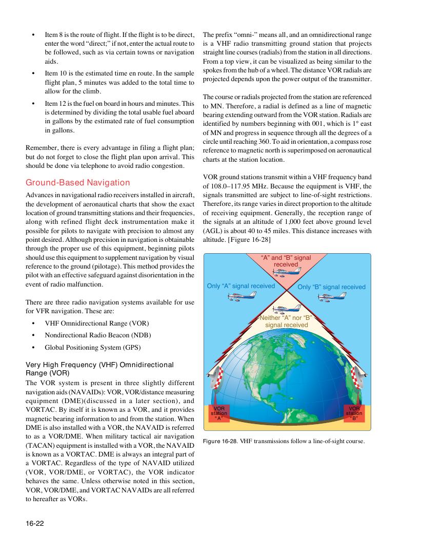
point desired. Although precision in navigation is obtainable altitude. [Figure 16-28]
through the proper use of this equipment, beginning pilots
should use this equipment to supplement navigation by visual “A” and “B” signal
reference to the ground (pilotage). This method provides the received
pilot with an effective safeguard against disorientation in the
event of radio malfunction.
Only “A” signal received Only “B” signal received
There are three radio navigation systems available for use
for VFR navigation. These are:
Neither “A” nor “B”
• VHF Omnidirectional Range (VOR)
signal received
• Nondirectional Radio Beacon (NDB)
• Global Positioning System (GPS)
Very High Frequency (VHF) Omnidirectional
Range (VOR)
The VOR system is present in three slightly different
navigation aids (NAVAIDs): VOR, VOR/distance measuring
equipment (DME)(discussed in a later section), and
VORTAC. By itself it is known as a VOR, and it provides VOR VOR
station station
magnetic bearing information to and from the station. When “A” “B”
DME is also installed with a VOR, the NAVAID is referred
to as a VOR/DME. When military tactical air navigation
Figure 16-28. VHF transmissions follow a line-of-sight course.
(TACAN) equipment is installed with a VOR, the NAVAID
is known as a VORTAC. DME is always an integral part of
a VORTAC. Regardless of the type of NAVAID utilized
(VOR, VOR/DME, or VORTAC), the VOR indicator
behaves the same. Unless otherwise noted in this section,
VOR, VOR/DME, and VORTAC NAVAIDs are all referred
to hereafter as VORs.
16-22