FAA-H-8083-25C · Source PDF page 226
Flight Instruments
Magnetic Compass Induced Errors · PHAK page 8-24
Searchable transcription
card from its backside. When the pilot is flying north, as the the two poles are aligned, and there is no variation. East
compass indicates, east is to the pilot’s right. On the card, of this line, the magnetic North Pole is to the west of the
“33,” which represents 330° (west of north), is to the right of geographic North Pole and a correction must be applied to
north. The reason for this apparent backward graduation is a compass indication to get a true direction.
that the card remains stationary, and the compass housing and
the pilot rotate around it. Because of this setup, the magnetic Flying in the Washington, D.C., area, for example, the
compass can be confusing to read. variation is 10° west. If a pilot wants to fly a true course of
south (180°), the variation must be added to this, resulting in
Magnetic Compass Induced Errors a magnetic course of 190° to fly. Flying in the Los Angeles,
The magnetic compass is the simplest instrument in California area, the variation is 14° east. To fly a true course
the panel, but it is subject to a number of errors that must of 180° there, the pilot would have to subtract the variation
be considered. and fly a magnetic course of 166°. The variation error does
not change with the heading of the aircraft; it is the same
Variation anywhere along the isogonic line.
The Earth rotates about its geographic axis; maps and charts
Deviation
are drawn using meridians of longitude that pass through the
geographic poles. Directions measured from the geographic The magnets in a compass align with any magnetic field.
poles are called true directions. The magnetic North Pole to Some causes for magnetic fields in aircraft include flowing
which the magnetic compass points is not collocated with electrical current, magnetized parts, and conflict with the
the geographic North Pole, but is some 1,300 miles away; Earth’s magnetic field. These aircraft magnetic fields create
directions measured from the magnetic poles are called a compass error called deviation.
magnetic directions. In aerial navigation, the difference
between true and magnetic directions is called variation. This Deviation, unlike variation, depends on the aircraft heading.
same angular difference in surveying and land navigation is Also unlike variation, the aircraft’s geographic location
called declination. does not affect deviation. While no one can reduce or
change variation error, an aviation maintenance technician
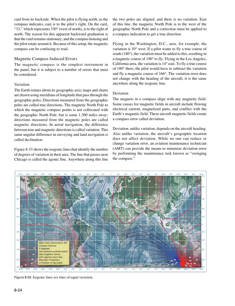
Figure 8-33 shows the isogonic lines that identify the number (AMT) can provide the means to minimize deviation error
of degrees of variation in their area. The line that passes near by performing the maintenance task known as “swinging
Chicago is called the agonic line. Anywhere along this line the compass.”
180˚W 165˚W 150˚W 135˚W 120˚W 105˚W 90˚W 75˚W 60˚W 45˚W 30˚W 15˚W 0˚ 15˚E 30˚E 45˚E 60˚E 75˚E 90˚E 105˚E 120˚E 135˚E 150˚E 165˚E 180˚W
70˚N -10 -40 -10 10 70˚N
-30 20
0 10
60˚N 60˚N
-20 -10
20
45˚N 45˚N
0
30˚N 0 30˚N
10
15˚N 0 15˚N
0˚ 10 -10 -20 -10 0˚
0 -10
15˚S -20 15˚S
-30
10
20
30˚S 30˚S
Main field declination (D) 20
Contour interval:
30 2 degrees 30
45˚S red contours positive (east) 10 -60 45˚S
40 b p l i u nk e ( n a e g g o a n t i i c ve ) z ( e w r e o s l t i ) ne. 20 -70 50 40
6
7
0
0
˚
˚
N
N 80 70 60
50 M e
P
r
o
c
s
a
i
t
t
o
io
r
n
P
o
ro
f
j
d
e
i
c
p
t i
p
o
o
n
l
.
es -20 -30 -40 -50
-80
-110
-1
-
0
12
0
0
-9
-
0
130 130 100 1
7
1 9 0
0
0 80
60
7
6
0
0
˚
˚
N
N
180˚W 165˚W 150˚W 135˚W 120˚W 105˚W 90˚W 75˚W 60˚W 45˚W 30˚W 15˚W 0˚ 15˚E 30˚E 45˚E 60˚E 75˚E 90˚E 105˚E 120˚E 135˚E 150˚E 165˚E 180˚W
Figure 8-33. Isogonic lines are lines of equal variation.
8-24