FAA-H-8083-25C · Source PDF page 300
Weather Theory
Atmospheric Stability · PHAK page 12-16
Searchable transcription
20,000 AGL
6,500 AGL
12-16
sduolc
hgiH
sduolc
elddiM
sduolc
woL
Cirrocumulus
Cirrostratus
Cumulonimbus
Cirrus
Altostratus Altocumulus Clouds with vertical development
Stratocumulus
Towering Cumulus
Stratus Nimbostratus
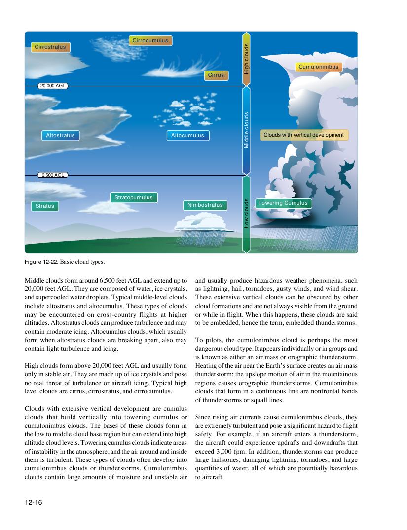
Figure 12-22. Basic cloud types.
Middle clouds form around 6,500 feet AGL and extend up to and usually produce hazardous weather phenomena, such
20,000 feet AGL. They are composed of water, ice crystals, as lightning, hail, tornadoes, gusty winds, and wind shear.
and supercooled water droplets. Typical middle-level clouds These extensive vertical clouds can be obscured by other
include altostratus and altocumulus. These types of clouds cloud formations and are not always visible from the ground
may be encountered on cross-country flights at higher or while in flight. When this happens, these clouds are said
altitudes. Altostratus clouds can produce turbulence and may to be embedded, hence the term, embedded thunderstorms.
contain moderate icing. Altocumulus clouds, which usually
form when altostratus clouds are breaking apart, also may To pilots, the cumulonimbus cloud is perhaps the most
contain light turbulence and icing. dangerous cloud type. It appears individually or in groups and
is known as either an air mass or orographic thunderstorm.
High clouds form above 20,000 feet AGL and usually form Heating of the air near the Earth’s surface creates an air mass
only in stable air. They are made up of ice crystals and pose thunderstorm; the upslope motion of air in the mountainous
no real threat of turbulence or aircraft icing. Typical high regions causes orographic thunderstorms. Cumulonimbus
level clouds are cirrus, cirrostratus, and cirrocumulus. clouds that form in a continuous line are nonfrontal bands
of thunderstorms or squall lines.
Clouds with extensive vertical development are cumulus
clouds that build vertically into towering cumulus or Since rising air currents cause cumulonimbus clouds, they
cumulonimbus clouds. The bases of these clouds form in are extremely turbulent and pose a significant hazard to flight
the low to middle cloud base region but can extend into high safety. For example, if an aircraft enters a thunderstorm,
altitude cloud levels. Towering cumulus clouds indicate areas the aircraft could experience updrafts and downdrafts that
of instability in the atmosphere, and the air around and inside exceed 3,000 fpm. In addition, thunderstorms can produce
them is turbulent. These types of clouds often develop into large hailstones, damaging lightning, tornadoes, and large
cumulonimbus clouds or thunderstorms. Cumulonimbus quantities of water, all of which are potentially hazardous
clouds contain large amounts of moisture and unstable air to aircraft.